How Can Drones Help With Land Surveys?
Andrew Chong • 2024-04-03
Explore the transformative impact of drone technology on land surveying, offering faster, more accurate, and cost-effective methods compared to traditional techniques. This article delves into the benefits of using drones for comprehensive land analysis, enhancing safety, efficiency, and decision-making in construction, real estate, and land development sectors.
Land surveying is a critical aspect of construction, real estate, and land development. It involves the measurement and mapping of land boundaries, contours, and features, such as buildings, trees, and waterways. Traditionally, land surveying required workers to physically walk or use instruments to measure the land. However, with the advancement of drone technology, land surveys have become more efficient, cost-effective, and accurate. In this article, we will explore how drones can help with land surveys.
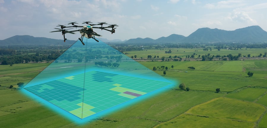
- Faster and More Efficient: One of the primary benefits of using drones for land surveys is that they are much faster and more efficient than traditional surveying methods. Drones can cover large areas in a short amount of time, capturing high-resolution images and data that can be processed quickly. This means that surveys can be completed in a fraction of the time it would take using traditional methods, saving time and money.
2. Higher Accuracy: Drones equipped with high-quality cameras and sensors can capture highly accurate data, resulting in more precise and detailed land surveys. The data collected by drones can be used to create 3D models of the land, which can be used to identify potential issues such as drainage problems, vegetation growth, and soil erosion. This allows for more informed decision-making and reduces the risk of costly mistakes during construction or land development.
3. Safer Surveying: Land surveying can be a hazardous job, especially when workers need to access difficult or dangerous terrain. Using drones for land surveys eliminates the need for workers to physically access these areas, reducing the risk of accidents and injuries. This is particularly useful in rugged or remote areas that may be difficult to access using traditional surveying methods.
4. Cost-Effective: Using drones for land surveys is cost-effective compared to traditional surveying methods. Drones are relatively inexpensive to operate and require minimal equipment and personnel. The use of drones for surveys reduces the need for expensive equipment and personnel, making land surveys more affordable for businesses and individuals.
5. Real-Time Monitoring: Drones can provide real-time monitoring of land surveys, allowing for instant feedback on the progress of the survey. This allows for faster decision-making and adjustments to be made if needed. The real-time data collected by drones can also be shared with stakeholders, such as clients, investors, and regulatory bodies, providing greater transparency and accountability.
6. Versatility: Drones can be used for a wide range of land surveying applications, including topographic surveys, boundary surveys, and site inspections. They can also be used to inspect hard-to-reach areas, such as roofs, towers, and power lines, which may be difficult or dangerous to access using traditional surveying methods.
In conclusion, drones have revolutionized the land surveying industry, providing faster, more accurate, and cost-effective surveys. Drones also offer a safer way to survey land, reducing the risk of accidents and injuries. As drone technology continues to advance, we can expect to see even more applications for drones in land surveying and land development.
See More Posts


Discovering location intelligence, one layer at a time.
Solutions
Oblique
Copyright © 2024 Geomapic Sdn Bhd. All rights reserved.